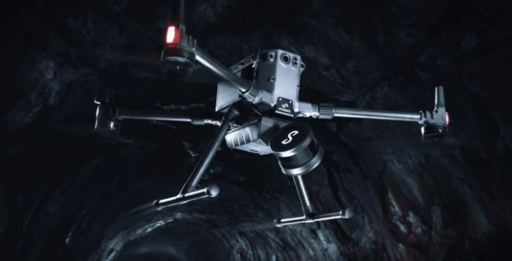
Emesent AEC solutions

Premium Headphones
Experience crystal-clear audio with our premium wireless headphones featuring active noise cancellation.
 en
en
Trimble Business Center
Use Hovermap point cloud data with Trimble Business Center (TBC) to leverage high-quality 3D scans in a precise and efficient workflow, improving accuracy, enhancing workflow efficiency, and supporting complex infrastructure and survey projects.
TBC can process, analyze, and integrate Hovermap data with other geospatial datasets, such as GNSS and total station data, to create accurate terrain models, maps, and 3D designs. TBC’s robust tools streamline large dataset management, automate feature extraction, and enable seamless collaboration.
Agisoft Metashape
Hovermap LiDAR data integrates with Agisoft Metashape to enhance photogrammetry workflows by combining detailed point clouds with high-resolution imagery.
Metashape processes Hovermap’s LiDAR data alongside aerial or ground photos to create accurate, georeferenced 3D models and maps. This improves data accuracy, fills gaps in visual datasets, and supports applications like surveying, construction, and asset inspection.
Bentley
Hovermap LiDAR data integrates seamlessly with Bentley Systems’ software, such as ContextCapture and MicroStation, to enhance 3D modeling and infrastructure workflows. Detailed Hovermap point clouds can be imported to create accurate digital twins, terrain models, and complex structures.
This integration supports visualization, analysis, and design optimization for infrastructure projects, improving collaboration, precision, and decision-making.
Cintoo Cloud
Utilize Hovermap’s 3D data with Cintoo Cloud’s tools for in-depth analysis, including sectioning, distance measurements, annotations, and comparisons with previous scans or BIM models if needed. You can also invite collaborators to view or edit the point cloud data, enabling a collaborative workflow within the platform.
Pointerra 3D
Transform Hovermap 3D data into actionable insights with Pointerra3D, simplifying complex datasets into detailed analytics and visualizations. With instant cloud access, it enhances collaboration and remote analysis.
Create precise digital twins of physical assets—such as electrical systems and circuits—for simulations, performance testing, and risk assessments, accelerating project timelines and enabling smarter, data-driven engineering solutions.
PointCab
Hovermap LiDAR data integrates with PointCab to simplify processing and analysis of 3D point clouds. PointCab’s software imports Hovermap’s detailed scans and transforms them into CAD-ready outputs. This integration enables efficient workflows for surveying, architecture, and construction projects, enhancing visualization, measurement accuracy, and compatibility with various CAD and BIM platforms.
Prevu3D
Combine Hovermap point cloud data with Prevu3D to create immersive 3D models for industrial and infrastructure settings. Hovermap’s LiDAR captures detailed scans in GPS-denied environments, enabling the creation of interactive digital twins when imported into Prevu3D.
These models support virtual walkthroughs, spatial planning, and collaborative design reviews, streamlining issue identification, layout optimization, and remote project management.
Revit
Hovermap LiDAR data integrates with Autodesk Revit to streamline workflows for BIM projects. Detailed point clouds captured by Hovermap can be imported into Revit, serving as a foundation for creating precise 3D models.
This integration supports as-built documentation, clash detection, and design validation, enabling architects and engineers to efficiently model and manage complex structures within Revit’s environment.
Contact us if your platform of choice is not listed above.
Experience crystal-clear audio with our premium wireless headphones featuring active noise cancellation.
Learn more about Emesent’s award-winning Hovermap platform.